

Wednesday 2nd March, 2022
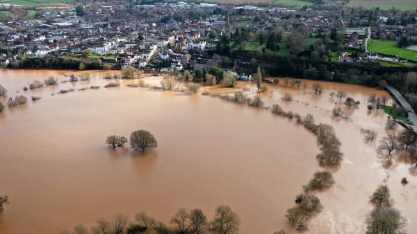
In the past fortnight, storms Dudley, Eunice and Franklin brought the first major flooding of the winter across the UK, including the Wye and Usk valleys.
While three named storms arriving within a week of each other is unusual, what is most peculiar and alarming about these is that they have created near record flooding from nowhere near record rainfall. In fact, the amount of rain that fell over the course of last week was not out of the ordinary.
Yet here we are faced with the kind of flood events we previously expected only once every 20 years.
It isn’t just the Wye and Usk either. In the upper Severn catchment the Afon Vrynwy was at the highest level for 53 years after a rainfall event that would be expected once every year. Meanwhile, the floods on the main stem of the Severn have in places been excess of those in 2000, which at the time were considered once-in-a-lifetime episodes.
What is very worrying about storms Dudley, Eunice and Franklin is that they caused extraordinary flooding from fairly ordinary amounts of rain
This past two weeks have shown all too clearly what happens when increasingly intensive rain falls on river catchments that are becoming less and less able to deal with it. And if the latest floods result from a once a year rainfall event, what will happen when we receive a one in twenty or one in fifty year event? This will happen sooner or later and the results will be unimaginable. In the past year we have seen what intensive rainfall can do in parts of Germany and Italy, which received 100-150mm in a day and 900mm in a day (181mm in an hour) respectively.

The Environment Agency’s Wye gauge from Hereford. Between 1945 and 2000, a level over 5 metres was recorded seven times. The Wye has exceeded that level three times in the past 13 months.
Climate change is, of course, the reason for more intensive rainfall. But at the same time, nearly everything that has been done to our river catchments in the past few decades has reduced their ability to store water, precisely at a time when we needed the exact opposite. An alarming proportion of the catchments’ soils are puddled, compacted and degraded (i.e. their organic matter levels have been much reduced which directly influences water holding capacity) through increasingly intensive agricultural practices.
Other areas of land have been managed in a way that purposely gets rid of water as fast as possible – from forestry drains in the headwaters to land drainage systems further downstream. One of the tragic ironies is that Government policies and grant schemes have encouraged these practices. The taxes of those now so badly affected by flooding have being spent on getting the water out of the catchment as fast as possible.

Puddling of the ground drastically reduces the ability of water to penetrate the soil, leading to more of it running straight off into a nearby river or stream
Reversing or preventing climate change from worsening would help this issue of course, but that will take time. It needs a coordinated worldwide effort which, if last November’s COP26 Conference is anything to go by, we are still some way from achieving (the latest UN report states our current changes are irreversible anyway). To solve this problem for the sake of the rivers, for farmers and society at large we need to look at ways of enabling the landscape to hold and delay water as it once did.
This isn’t some environmentalist pipe dream. Healthy soils can hold huge amounts of water. Around 80% of the Usk’s short and medium term rainfall storage is in the soil. We know that healthy soils containing high levels of organic matter can absorb 50-100mm of rain a day, to be released via springs and drains some hours or days later.
Areas of woodland can absorb even more. The Pontbren Project in Powys has shown that the strategic planting of tree shelter belts across upland slopes can reduce surface run-off by allowing it to soak more quickly into the soil. Their investigations have discovered that in some woodland areas, water soaked into the soil 60 times quicker than in nearby grassland pastures.
Everyone and everything benefits from healthier soils that absorb more water – farmers, local residents and river ecology. There are no losers.
 There are other measures that can be taken to reduce the volume and speed of water washing off the landscape too:
- Avoiding fields with high risk topography and connectivity to watercourses for high risk crops
- Planting hedges across slopes
- Moving gate ways and directing vehicle movements away from overland flow lines
- Maintaining cover on arable fields over winter, for example under-sowing maize (photo right)
- Adopting grazing techniques that enable rest and recovery periods for soils, rather than set stocking
- Reducing cultivations and working to rebuild depleted organic matter and repair poor structure
- Planting areas where overland flow occurs to become rough, tussocky grass, scrub or trees.
It must be emphasised, however, that all these measures have to be undertaken in the right part of the catchment. Delaying water from entering a river at the bottom of its catchment without doing the same at top can actually increase flood risk in the lower reaches.

Moving gate ways and directing vehicle movements away from overland flow lines is one measure that can be taken to reduce the volume and speed of water washing off the landscape
Unfortunately, politics or more specifically, political boundaries also need to be inserted into the flood prevention mix. In the past, much of the flood alleviation money was spent in the area it was allocated to, usually in building hard defences. However, it is slowly being accepted that funds allocated to one area’s flood defence are often better spent outside that area, i.e. further upstream. In the case of the Wye (and Severn), it means that much of England’s flood defence budget would be better spent across the border in Wales.
Is this likely to happen? Quite simply, it has to if the UK is to avoid the kind of catastrophic flooding seen on mainland Europe in 2021. If anything demands a joined-up, whole catchment-based approach, it is flood management. Yet despite this, Welsh and English Government funds must still be spent on their respective side of the border.

If anything requires a catchment-wide approach without political or administrative boundaries, it is flood management.
While there have been some calls for a more catchment based approach recently (including Jesse Norman MP in Parliament), the dogma of regionalism and popularism within our political systems should not be underestimated either. Only this week a local councillor in Llangadog was reported as berating Natural Resources Wales for not dredging the Tywi to prevent the town’s recent floods. Even if siltation was the cause of the flooding, there appeared to be no thought about how the sediment and floodwater got there in the first place and no appreciation that measures taken outside his “patch” could help stop it happening again.
It is not just local people and businesses that would benefit enormously from effective, natural, catchment-wide flood management. Our rivers would too. Severe flooding events damage their ecology, as do the increasing number of low water events that are made worse by the landscape’s inability to hold back water during wet periods and release it in drier times.
Farmers would also benefit. Their soils would be healthier and their businesses more profitable. Quite simply, everyone wins. There are no losers.
One of the Foundation’s current projects is working with the Ministry of Defence to reduce flood risk in the Usk valley by implementing natural flood management techniques. The MOD control large areas of land (shown in blue in the map above) on the Eppynt, the range of hills on the northern side of the upper Usk catchment where some upper Usk tributaries have their headwaters. We will be measuring closely the efficacy of this project but the benefits are likely to be felt miles downstream in entirely different administrative areas.
But doing this on a catchment the size of the Wye or Usk requires scientific knowledge of where natural flood management work would be best located and, of course, the funds to carry it out. The Foundation is using its soil, water and Geographical Information Systems (GIS) expertise to identify potential sites and to work with farmers and landowners such as the Ministry of Defence. The latter manage the Eppnyt (the range of hills on the northern side of the upper Usk valley), whose streams have a big influence on flooding further downriver.
We are also working with landowners in the Monnow, upper Wye and other parts of the upper Usk to determine what natural flood management measures can be undertaken and where.
Such partnerships will be crucial if the land in our catchments is to be managed in ways that alleviate floods rather than exacerbate them.
Further reading:
“NRW ‘in total denial’ after more serious flooding in Llangadog”
